The UK is bracing for a tumultuous weather assault this week as a powerful Atlantic jet stream unleashes a barrage of strong winds, heavy rain, and widespread snow across its northern regions. From the Scottish Highlands down to North Wales and across northern England, including areas around Liverpool, residents are being warned to prepare for significant disruption and a sharp plunge into colder conditions. This isn't just blustery weather; it's a dramatic atmospheric event shaped by a high-speed phenomenon thousands of feet above us.
Why is the UK Facing Such Extreme Weather Right Now? Understanding the Atlantic Jet Stream's Impact
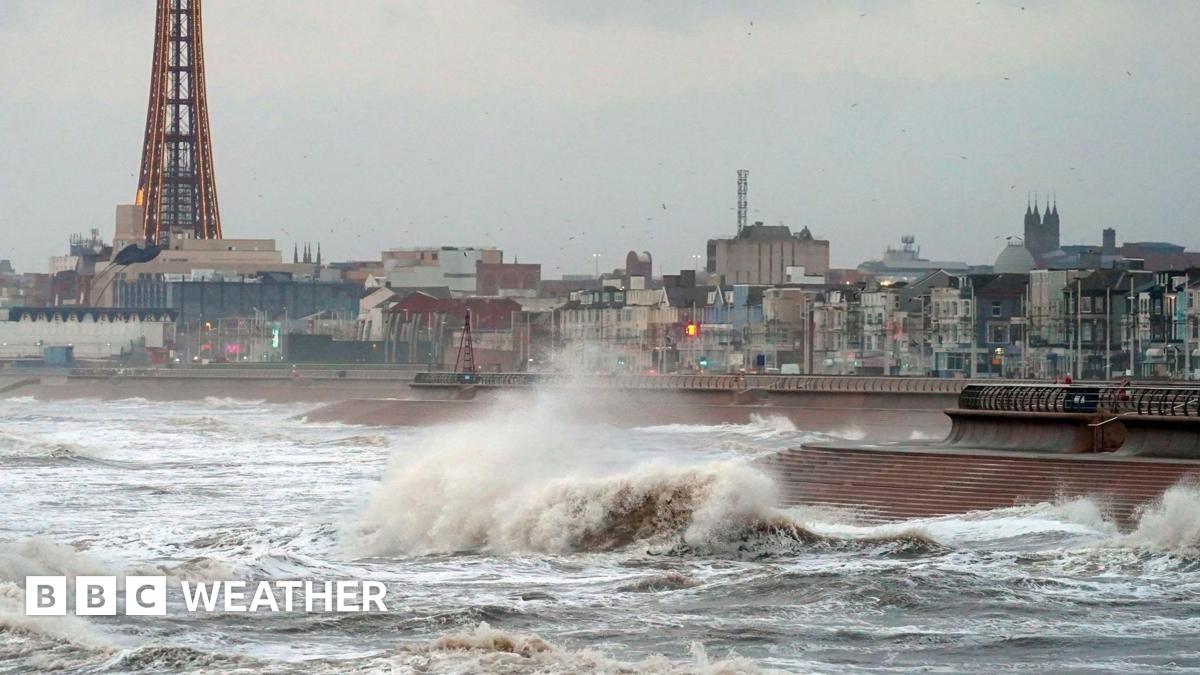
Ever wonder why our weather suddenly turns from mild to wild? The culprit behind this week's fierce conditions is a supercharged Atlantic jet stream, currently hurtling across the ocean at an astonishing 220mph. This high-altitude river of air acts like a conveyor belt, driving intense areas of low pressure towards the UK. While the epicenters of these powerful lows might be far to our north-west, their sheer force is still close enough to send zones of severe winds and precipitation sweeping across the British Isles.
We saw a preview of this power on Wednesday, with gales widely reported across Scotland. Gusts peaked at 74mph in South Uist Range in the Hebrides, and 68mph battered Orkney, leading to immediate ferry cancellations. This was merely the overture to what's expected to be a much more disruptive performance.
Met Office Warnings: What You Need to Know About This Week's Gales and Snow Across Northern England & Scotland
The Met Office has wasted no time in issuing a raft of yellow warnings, underscoring the severity of the incoming weather. These aren't mere advisories; they're calls to action for anyone planning travel or outdoor activities in affected areas.
The Immediate Threat: How Strong Winds Are Impacting Travel in Northern UK Today
Yellow warnings for strong winds have been in effect since Thursday morning, impacting North Wales, northern England (including the broader Liverpool region), and large parts of Scotland. While Northern Ireland experienced its peak gusts earlier in the morning (6 AM - 12 PM GMT), other regions will continue to feel the brunt of the gales well into the evening.
Expect widespread gusts of 50-60mph, with some exposed areas – particularly in northern England – potentially seeing gusts exceeding 70mph for short periods. Crucially, these aren't just coastal phenomena; the powerful winds will extend far inland, impacting areas well east of the Pennines and Cheviot Hills.
The travel network is already feeling the strain:
- Ferries: Delays and cancellations are highly likely for Scottish ferry services. Passengers are urged to check for updates before heading out.
- Roads: High-sided vehicles are already barred from the Woodhead Pass over the Pennines. Northern stretches of major arteries like the M6, A68, and A1 are predicted to present some of the most challenging driving conditions.
Snow and Ice Risk: Where and When Wintry Conditions Will Hit Scotland and Northern England
As the initial wave of strong winds subsides with the passage of a cold front, a new threat emerges: a sharp drop in temperatures bringing significant snow and ice. This colder air mass will usher in frequent wintry showers from Thursday night right through to Friday.
An additional yellow warning for snow and ice has been issued for central and north-west Scotland, valid from midnight GMT Friday until 9 AM. Within this window, 2-5 cm of snow is expected widely, with higher ground above 350 meters potentially seeing up to 10 cm accumulate. But it's not just Scotland: wintry showers, complete with hail and even the odd crack of thunder, are also forecast for high ground in Northern Ireland, northern England, and North Wales. While these showers will be frequent, the gusty winds will ensure they are fast-moving, preventing prolonged downpours in any single location.
Beyond Friday: What Does the Weekend Weather Forecast Hold for the UK North?
Don't expect a quick rebound to calmer conditions. The forecast for the weekend indicates that the unsettled pattern will persist. Further strong winds and wintry showers are on the cards for Sunday and Monday, suggesting that any respite will be short-lived. This means potential continued disruption and the need for ongoing vigilance for those in affected areas.
Why This Buzz: Prepare for Impact – Staying Safe During the Adverse Weather Conditions
This isn't just about a cold snap; it's about significant weather that will impact daily life and travel. WhyThisBuzz urges residents in the affected northern UK regions to take these warnings seriously.
- Check Travel: If you must travel, verify routes and public transport schedules before you leave. Expect delays and cancellations, especially on ferries and higher routes.
- Secure Property: High winds can turn loose items into projectiles. Secure garden furniture, bins, and any other items that could be blown away.
- Drive Safely: Be acutely aware of driving conditions. Gusty crosswinds can be extremely dangerous for all vehicles, especially high-sided ones. Ice and snow will make roads treacherous.
- Stay Informed: Keep an eye on local Met Office updates and use reliable weather apps for the latest hour-by-hour forecasts in your specific area.
This weather event is a powerful reminder of nature's force. Staying prepared and informed is your best defense against its impact.