From Summer Tease to Winter Rage: Unpacking Winter Storm Iona's Impact
Just when parts of the central and eastern U.S. were basking in record warmth and battling severe thunderstorms, Mother Nature decided to hit the reset button—hard. Enter Winter Storm Iona, a meteorological marvel named by The Weather Channel, that's delivering a gut-punch of blizzard conditions, historic snowfall, and dangerously high winds across the Upper Midwest and Great Lakes, before unleashing an arctic blast all the way to the East and South. This isn't just a storm; it's a textbook example of March's chaotic weather swings, and it’s creating a whirlwind of disruption across millions of lives.
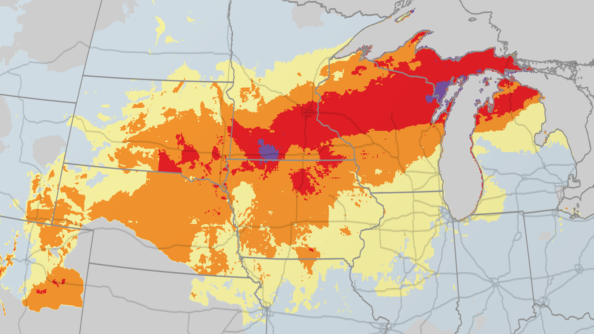
Record-Breaking Snowfall: How Much to Expect in Wisconsin and Michigan?
The numbers are staggering. Snow has been falling at an astonishing rate of 1 to 3 inches per hour in parts of Wisconsin and Michigan. Already, areas from southern Minnesota to central Wisconsin have seen over 20 inches of accumulation, with Marinette, Wisconsin reporting a jaw-dropping 28 inches.
But it’s not over. Forecasts indicate that parts of southern Minnesota, central and northern Wisconsin, and vast stretches of Lower and Upper Michigan could see over a foot of snow, with some localized spots potentially buried under 1 to 3 feet. Key cities like Green Bay, Marquette, and Mackinac Island are in the bullseye. Marquette, in particular, has already tallied over 214 inches of snow since October 1st, marking one of its top five snowiest seasons on record. NOAA even suggests this storm could shatter 2-day snowfall records in northeastern Wisconsin, eastern Upper Michigan, and extreme northern Lower Michigan.
This isn't just about pretty snow; it's about impossible travel conditions. If you're in the western Great Lakes or upper Midwest, heed the warnings: consider delaying or canceling your travel plans through early Monday.
Beyond the Snow: High Wind Alerts and Widespread Power Outage Risks
As if record snow wasn't enough, Winter Storm Iona is a multi-threat event. Powerful winds are a critical component, raising high wind alerts across the impacted zones. These gusts aren't just an inconvenience; they pose significant risks:
- Blizzard Conditions: Coupled with heavy snow, these winds create whiteout conditions, making roads invisible and travel treacherous.
- Power Outages: The combination of strong winds, heavy, wet snow, and potential ice accumulation could lead to extensive tree damage and widespread power outages, particularly near the Great Lakes and along the immediate East Coast.
- Fire Danger: In areas where the cold front has yet to bring significant precipitation, these high winds could fan existing fires or spark new ones.
The danger isn't confined to the northern states. Even for those further south, the storm’s powerful low-pressure system is shoving a potent cold front rapidly eastward, promising a dramatic weather shift.
East Coast Braces for Rain, Thunderstorms, and Freezing Temperatures
While the Northeast won't see significant snowfall from Iona, don't think you're getting off easy. The East Coast will experience a dominant rain event, with strong to severe thunderstorms packing damaging winds possible from parts of the Northeast down to the Carolinas.
Meanwhile, the Ohio Valley and Appalachians could see a quick flip from rain to a burst of snow. And for a brief but dangerous period on Sunday, parts of extreme northern Iowa, southern Minnesota, southern Wisconsin, and Lower Michigan might experience a band of freezing rain and sleet, creating slick roads and further increasing the risk of ice-related tree damage and power outages before changing to rain, then back to snow.
Record-Breaking Cold Air: When and Where the Arctic Chill Will Hit Hardest
The ultimate "why it matters" of Winter Storm Iona extends far beyond the immediate blizzard. Beginning this weekend, a fresh, potent supply of cold air from Canada is diving southward, promising a brutal cold snap that will have staying power deep into St. Patrick's week.
- Monday: The cold air blankets the Plains and reaches the northern Gulf Coast. Highs across much of the Midwest will be stuck in the teens, 20s, and 30s.
- Tuesday: The arctic air sweeps through the entire East, even chilling Florida.
- St. Patrick's Day (March 17): Expect 20s and 30s across most of the Northeast and Midwest, while the Southeast shivers in the 40s and 50s.
Some subzero lows are possible in North Dakota, Minnesota, Wisconsin, and Michigan's Upper Peninsula on Monday and Tuesday. Even the Deep South, including parts of far northern Florida, is forecast to dip below the freezing mark Tuesday and Wednesday mornings. This could threaten daily record lows and cold highs, with a frost potentially reaching as far south as Mobile, Alabama, and New Orleans. Central Florida could even experience its coldest St. Patrick's Day highs on record, struggling to reach 60 degrees.
Is There a Break from Winter's Fury? The Long-Range March Weather Forecast
For those utterly exhausted by winter's relentless grip, especially after the brief tease of spring, there's a sliver of hope. Warmer air is expected to begin working its way eastward in the Plains by the middle of the upcoming week, potentially oozing further east later next week.
However, don't pack away the winter gear just yet. Longer-range models suggest that some chillier air might spill back into parts of the Midwest and Northeast by the weekend of March 21-22, or the week following. March, it seems, isn't quite done with its unpredictable nature.
Navigating the Extreme March Weather: What This Means for You
Winter Storm Iona is a stark reminder of how quickly weather patterns can pivot, especially in March. From disrupting travel and impacting power grids to creating potentially dangerous conditions for exposed populations, its effects are widespread and significant. For millions, the coming days will mean contending with extreme cold and the aftermath of heavy snowfall. Stay informed, take local weather warnings seriously, and prioritize safety. This isn't just a news story; it's a critical event impacting daily life across a huge swathe of the nation.